Eleven Charlotte areas compared: ZIP code, zoned high school and typical home value. CMS zones split several areas; check each address.
Last checked Oct. 11, 2026. Sources: OpenStreetMap place names and boundaries, Mecklenburg County GIS (historic districts, city limits, ZIP code boundaries and the CMS 2026-27 feeder boundaries), the N.C. Department of Public Instruction’s 2025-26 accountability data, the U.S. Census Bureau’s QuickFacts and Zillow Research.
Charlotte is a city of 903,844 people, by the Census Bureau’s 2020-2024 American Community Survey estimates, covering about 316 square miles of Mecklenburg County. I-77 runs north and south through it and I-85 runs northeast to southwest; the I-277 loop wraps around Uptown, and I-485 circles the city. The Lynx Blue Line runs from the UNC Charlotte campus through Uptown and South End to the south. Three facts shape where you live more than any neighborhood name:
- One school district, many zones. Charlotte-Mecklenburg Schools serves the whole county, including the towns around Charlotte, so school zones pay no attention to city limits. Zones follow parcels, and several areas in this guide are split between two high schools.
- ZIP codes are not neighborhoods. About 30 ZIP codes reach into the city. Among the 23 Charlotte ZIP codes in our Zillow file, typical home values in August 2026 ran from $299,346 in 28208 to $1,662,801 in 28207, according to Zillow.
- City or county. A Charlotte mailing address can be outside city limits. Only about 27% of ZIP 28278’s land is inside the city, according to Mecklenburg County’s maps. That changes your tax bill and who picks up your trash.
What this means for you
- Look up any address in the county’s CMS Boundary Search, or call CMS at 980-343-3000.
- Check whether a parcel is in the city on the county’s property search.
- Compare tax rates in our property tax guide and prices in our home prices guide.
The 11 areas at a glance
Zoned high school shares are of parcels in each area in the 2026-27 CMS feeder data; home values are the Zillow Home Value Index for August 2026, a modeled typical value for the middle third of homes, not a sale price.
| Area | ZIP code | Zoned high school | Typical home value in the ZIP |
|---|---|---|---|
| Uptown | 28202 | Myers Park (98%) | $405,678 |
| South End | 28203 | Myers Park (78%), Harding University (22%) | $675,347 |
| Dilworth | 28203 | Myers Park | $675,347 |
| Wesley Heights | 28208 | West Charlotte | $299,346 |
| Elizabeth | 28204 | Myers Park | $577,994 |
| Plaza Midwood | 28205 | Garinger (96%) | $458,468 |
| NoDa | 28205, 28206 | Garinger | $458,468 and $321,759 |
| Myers Park | 28207 | Myers Park | $1,662,801 |
| SouthPark | 28210, 28211 | South Mecklenburg (76%), Myers Park (24%) | $566,893 and $930,696 |
| University City | 28262 | Julius L. Chambers (82%), Mallard Creek (18%) | $340,394 |
| Steele Creek | 28273, 28278 | Olympic (51%), Palisades (49%) | $365,809 and $497,171 |
The citywide Charlotte figure was $392,573, down 1.1% on the year. School scores for each zoned school are on the area pages and in our schools guide.
Map
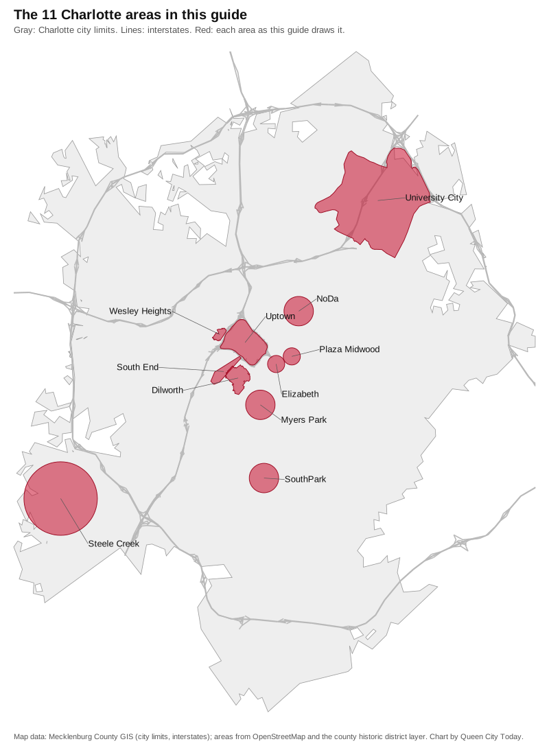
City limits and interstates from Mecklenburg County GIS; area shapes from © OpenStreetMap contributors and the county’s historic district layer. Where OpenStreetMap marks an area with a point only, the map shows the circle this guide used.
Uptown and the center
Uptown. The center city inside the I-277 loop, in four wards, with five Blue Line stations and the Gold Line streetcar. Mostly apartments and condominiums; zoned for Myers Park High. Things to do are in our Uptown Charlotte guide.
South End. The Blue Line and South Boulevard corridor just south of Uptown, with three stations and the Charlotte Rail Trail. Split between Myers Park and Harding University high schools.
Dilworth. A 0.69-square-mile National Register and local historic district around Latta Park, all zoned for Dilworth Elementary, Sedgefield Middle and Myers Park High.
Wesley Heights. A small local historic district just west of Uptown across I-77, with the Wesley Heights Greenway; zoned for West Charlotte High.
East of Uptown
Elizabeth. Hawthorne Lane, Seventh Street and Independence Park, with four Gold Line stops; zoned for Eastover Elementary and Myers Park High.
Plaza Midwood. Central Avenue and The Plaza, with a small local historic district to the north; split between Shamrock Gardens and Oakhurst elementary zones and mostly zoned for Garinger High.
NoDa. North Davidson and 36th streets, with the 36th Street Blue Line station, three county parks and the Cross Charlotte Trail; zoned for Garinger High.
South Charlotte
Myers Park. Queens Road and Queens University, with the Little Sugar Creek Greenway and Freedom Park nearby. ZIP 28207 had the highest typical value in our Zillow file.
SouthPark. The district around SouthPark Mall, with three supermarkets inside it and an extra 3.81-cent city service district tax on some parcels; split between South Mecklenburg and Myers Park high schools.
The edges of the city
University City. About 12 square miles around UNC Charlotte in the northeast, with four Blue Line stations and four greenways; mostly zoned for Julius L. Chambers High.
Steele Creek. Southwest Charlotte along Steele Creek Road, about 7 miles by road from the airport, split evenly between Olympic and Palisades high schools.
How we built this
- Which areas. We used only places a source names and puts on a map. OpenStreetMap draws boundaries for Uptown, South End, University City, Wesley Heights and the Dilworth Historic District, and tags Elizabeth, Plaza Midwood, NoDa, Myers Park, SouthPark and Steele Creek as district-level places with a single point. Mecklenburg County’s historic district layer draws Charlotte’s local historic districts, which we used for Dilworth and Wesley Heights. Where an area has only a point, we used a circle around it, with a radius of 0.35 to 1.5 miles depending on how spread out the area is, and each page says so.
- Left out. OpenStreetMap names more than 300 neighborhoods, subdivisions and hamlets in the Charlotte area, and the city’s neighborhood directory lists associations, but neither sets out larger districts for the whole city, so this guide covers 11 well-mapped areas, not every neighborhood. Ballantyne, Cotswold, Eastover and many others are not covered yet. We name no subdivisions.
- Schools. We counted every parcel inside each area in the CMS 2026-27 feeder boundary data that Mecklenburg County publishes, and took scores from the state’s 2025-26 accountability data. Zones change; check your own address.
- Distances are measured on OpenStreetMap roads with the OSRM routing engine to the Charlotte-Mecklenburg Government Center and Charlotte Douglas International Airport. They are distances, not drive times.
Comparing towns instead? See Charlotte vs Pineville vs Matthews vs Mint Hill, and our moving to Charlotte guide.
Frequently asked questions
What are the neighborhoods in Charlotte?
This guide covers 11 areas that OpenStreetMap or Mecklenburg County’s historic district map names and places: Uptown, South End, Dilworth, Wesley Heights, Elizabeth, Plaza Midwood, NoDa, Myers Park, SouthPark, University City and Steele Creek. Charlotte has many more named neighborhoods.
Which school district is my Charlotte address in?
Charlotte-Mecklenburg Schools serves the whole county, inside and outside the city. Your zoned schools depend on the parcel, not the neighborhood name; check the county’s CMS Boundary Search or call CMS at 980-343-3000.
Which Charlotte ZIP code has the highest home values?
Of the 23 Charlotte ZIP codes in our Zillow file, 28207, which covers Myers Park, had the highest typical value in August 2026, at $1,662,801. The citywide figure was $392,573.
Is every Charlotte mailing address inside the city?
No. About 30 ZIP codes reach into Charlotte, and some Charlotte ZIP codes are mostly outside it: only about 27% of ZIP 28278’s land is inside city limits, according to Mecklenburg County’s maps.
What is the population of Charlotte?
903,844, according to the Census Bureau’s 2020-2024 American Community Survey five-year estimates.
Have your say